

Hi guys,
I have some Dragon figures in the stash that include a figure who is supposed to be holding a piece of paper, probably a map, in his hand. This is consistent with the way I want to use the figure in the diorama, or else I would just change the arm.
Have any of you tried to make 1/35 scale maps/pieces of paper/etc.?
Obviously I can cut a small piece off of a regular piece of paper, but weathering it and making it look to scale is the real issue.
Figures
Military figures of all shapes and sizes.
Military figures of all shapes and sizes.
Hosted by Darren Baker, Mario Matijasic
Figure Holding Map

foyle99

Joined: April 18, 2017
KitMaker: 29 posts
Armorama: 22 posts
Posted: Friday, June 16, 2017 - 08:00 PM UTC

Armorsmith
Joined: April 09, 2015
KitMaker: 1,063 posts
Armorama: 1,000 posts
Posted: Friday, June 16, 2017 - 08:11 PM UTC
IIRC Verlinden made maps as did an outfit called Alexander the Great although both are now defunct. I am sure there are scale maps out there but the manufacture(s)escape me at the moment. Check ETA Diorama as they make some paper products that were just recently reviewed here on Armorama.

165thspc

#521
Joined: April 13, 2011
KitMaker: 9,465 posts
Armorama: 8,695 posts
Posted: Friday, June 16, 2017 - 10:16 PM UTC
I know this is a long shot but . . . I have a small section of an actual WWII German printed map of an area in France. I would be happy to do a high-res scan of this piece and e-mail the file to you if that might help? It would be typical that a commander would refold a map to show only that section he was dealing with at the time.
The portion of map covers from the French Coast, east to Mereville, on to Burthecourt then over to Saffais and south to St. Remimont.
The portion of map covers from the French Coast, east to Mereville, on to Burthecourt then over to Saffais and south to St. Remimont.


deathdork
Joined: March 26, 2007
KitMaker: 314 posts
Armorama: 296 posts
KitMaker: 314 posts
Armorama: 296 posts
Posted: Friday, June 16, 2017 - 11:39 PM UTC
You might consider perusing the Duplicata website, They have a variety of map options
foyle99
Joined: April 18, 2017
KitMaker: 29 posts
Armorama: 22 posts
Posted: Monday, June 19, 2017 - 07:56 PM UTC
Quoted Text
I know this is a long shot but . . . I have a small section of an actual WWII German printed map of an area in France. I would be happy to do a high-res scan of this piece and e-mail the file to you if that might help? It would be typical that a commander would refold a map to show only that section he was dealing with at the time.
The portion of map covers from the French Coast, east to Mereville, on to Burthecourt then over to Saffais and south to St. Remimont.
Thank you, Michael, that is a very kind offer. If you could do that I would be very grateful. If you PM me I will give you my email address.
165thspc
#521
Joined: April 13, 2011
KitMaker: 9,465 posts
Armorama: 8,695 posts
Posted: Monday, June 19, 2017 - 08:26 PM UTC
Happy to. What scale/finished size will the map end up being reduced to?
F.Y.I. - I happen to have picked up a period 1944 First Army Engineer's Christmas Card on eBay. Only the second one I have ever seen. Appearently the French print shop they used had been previously printing maps for the Germans before liberation. When you unfold the card you see the map section on the reverse side. So it must have been decided to print the Xmas Card on the blank side of the map stock as a way of thumbing their noses at the Germans. I think it was a rather cool use of captured war booty and a nice way of telling the folks back home were they were at that time.

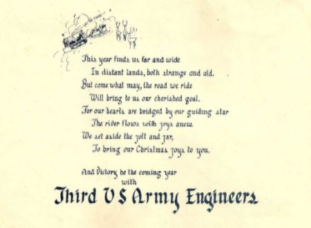
F.Y.I. - I happen to have picked up a period 1944 First Army Engineer's Christmas Card on eBay. Only the second one I have ever seen. Appearently the French print shop they used had been previously printing maps for the Germans before liberation. When you unfold the card you see the map section on the reverse side. So it must have been decided to print the Xmas Card on the blank side of the map stock as a way of thumbing their noses at the Germans. I think it was a rather cool use of captured war booty and a nice way of telling the folks back home were they were at that time.


165thspc
#521
Joined: April 13, 2011
KitMaker: 9,465 posts
Armorama: 8,695 posts
Posted: Monday, June 19, 2017 - 09:20 PM UTC
GI reading a copy of YANK. This was printed in black on regular typing paper and then stained with deluted coffee.


165thspc
#521
Joined: April 13, 2011
KitMaker: 9,465 posts
Armorama: 8,695 posts
Posted: Monday, June 19, 2017 - 09:27 PM UTC
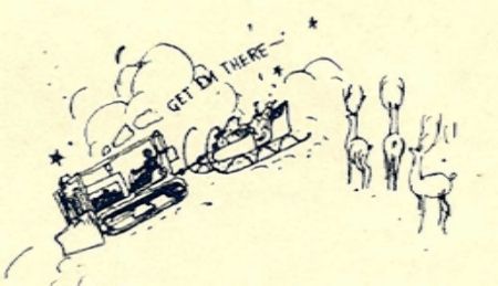
Left half of map.
Sorry - what I took for coast line was just the map maker's way of showing the edge of the map coverage. This map is actually an Eastern section of France just South of Nancy near the Swiss and German borders. (Sad state of affairs for someone who at one time was a map maker himself!)

Sorry - what I took for coast line was just the map maker's way of showing the edge of the map coverage. This map is actually an Eastern section of France just South of Nancy near the Swiss and German borders. (Sad state of affairs for someone who at one time was a map maker himself!)


Biggles2

Joined: January 01, 2004
KitMaker: 7,600 posts
Armorama: 6,110 posts

Posted: Monday, June 19, 2017 - 10:12 PM UTC
In 1/35, a map, is a map, is a map...especially when it's folded for holding. Any features or printing are way too small to recognize. I took a piece of tracing paper because of it's thinness (for scale), and taped it all around to a piece of regular printing paper, keeping it nice and flat. Tracing paper (or onion skin), by itself, is so thin it just gets wrecked in the printer. Downloaded a suitable map image from the internet and printed it on the tracing/printing paper combo. You can also copy directly from commercially available 1/35 maps which are printed on way over-scale paper. Tracing paper is already off-white so no need to stain it later.

165thspc
#521
Joined: April 13, 2011
KitMaker: 9,465 posts
Armorama: 8,695 posts
Posted: Monday, June 19, 2017 - 11:47 PM UTC
Feel free to download this medium-res map image that I have posted here above. After all it is historically correct for early to mid WWII ETO and as such constitutes un-copyrighted spoils of war. The finished map will represent a larger map folded up so there is little need to worry about scale thickness.
By the way, in German:
Frankreich = France
By the way, in German:
Frankreich = France
 |

WEB HOSTING BY


Copyright ©2021 Armorama and Kitmaker Network, a subsidiary of Silver Star Enterprises
All Rights Reserved. Please read our Conditions of Use and Privacy Policy.
All Rights Reserved. Please read our Conditions of Use and Privacy Policy.